
Sonoma Land Trust
Sea Change: Redrawing the Map of San Francisco Bay
Julian Meisler, Baylands Program Manager, Sonoma Land Trust
Note: This story was originally published in North American Bird Conservation Initiative’s (NABCI) Winter 2016 issue of The All-Bird Bulletin, titled Developing Partnerships with Land Trusts for Bird Conservation and has been adapted for this website.
Why Bird Conservation?
The San Francisco Bay Estuary is the largest estuary on the west coasts of North and South America. More than one million resident waterfowl and shorebirds depend on its varied habitats while at least a million more migrate to or through it. While significant, these bird numbers are reduced from historic times when the expanse of tidal marsh was far greater. Approximately ninety percent of the bay’s marshes were lost between 1850 and 1960, and thus many birds dependent on the marshes for foraging and breeding, like the threatened California Black Rail and endangered Ridgway’s Rail, have suffered severe population declines.
Sonoma Land Trust (SLT), a small, non-governmental organization working to conserve the lands and waters of Sonoma County, California, has been invested in northwestern San Francisco Bay shoreline conservation and restoration since the mid-1980s. It has protected more than 7,000 acres of diked baylands (reclaimed tidal wetlands) and uplands directly adjacent to the Bay.
Spotlight Resource: Partnership with a Local Bird Conservation Organization
One of SLT’s greatest conservation achievements began in 2003, when a plan to build a Las Vegas-style casino on the shoreline lit a fire under the conservation community. Not only would such a development permanently alter the region’s rural character, it stood in the face of every major conservation plan for the Bay. The proposed site was entirely within the historic Bay margin—the area once part of the bay but reclaimed for agriculture, industry, and other development. SLT and partners, such as the San Francisco Bay Joint Venture, worked to convince the project proponents, a local Native American tribe, that this proposal would be at odds with conservation initiatives. The efforts were rewarded not only with the tribe relinquishing its right to purchase the site but it also donated its purchase option valued at $4.2 million.
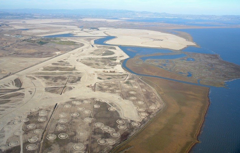
Over the next two years, SLT raised a total of $20 million to buy the property and, conveniently, the one next door. Collectively the 2,327-acre site is known as Sears Point. Unique among nearly all shoreline conservation properties, Sears Point extends deep into the adjacent uplands reaching elevations of nearly 400 feet. Some nine miles of riparian corridors traverse its grasslands, willow groves, and broad plains of seasonal wetlands to connect upland to Bay.
The purchase set in motion a ten-year effort to plan, permit, and fundraise for a large-scale restoration known as the Sears Point Restoration Project. The nearly 1,000-acre portion slated for tidal wetland restoration housed farm buildings, hay fields, and an upland game bird hunting club. The plan was to remove all the human built structures, create some new and innovative natural features to hasten the evolution of the new marsh, and then to breach the century-old levee to bring back the tides.
SLT hired some of the best minds in the Bay to design a project that incorporated lessons learned from previous projects and anticipated sea level rise (https://www.youtube.com/watch?v=C7KCslWsqSE for more information about the project). Five years into the process, SLT partnered with Ducks Unlimited (DU) to bring its experience and expertise to the project.
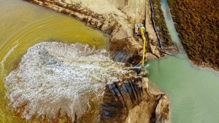
Closely following the original design, SLT and DU built a new 2.5-mile levee, whose gentle slopes would not only serve a necessary flood protection role, but also provide high tide refugia for marsh wildlife during extreme tides and storm surges. The levee was built with soil dug on site during the excavation of six miles of new channels. Over 500 “marsh mounds” were built within the site to break up wind waves that might prevent tidally borne sediment from settling out of the incoming bay waters—sediment that will be needed to raise the site more than six feet to reach marsh plain elevation, the elevation at which vegetation grows. These were but a few of the construction activities leading up to October 25, 2015, when the historic levee was finally breached.
Birders flocked to the site and emails to SLT looked like this: “There are huge numbers of shorebirds, including stilts, avocets, curlews, etc., etc. The same goes for gulls. The wintering ducks have not arrived but there were a few Mallards, pintails and shovelers. There were also egrets, herons, cormorants, lots of Killdeer and pipits. A few raptors were also around. In short, this is going to be a wonderful place for shorebirds, waterfowl and waders.”
In the weeks that followed, the ducks arrived. And in years, the marsh will begin to emerge, giving home to rails and other marsh-dependent wildlife—all resulting from the work of a single small land trust. Nationwide more than 1,700 land trusts like SLT have protected 37 million acres—an area roughly the size of all the New England states combined. The cumulative effect of this work is tremendous. The Sears Point Restoration Project is but one example of what local organizations can do to meet global challenges.