
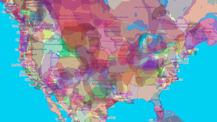
Native Land Map
Native Land Digital is a Canadian not-for-profit organization, incorporated in December 2018. Native Land Digital is Indigenous-led, with an Indigenous Executive Director and Board of Directors who oversee and direct the organization. Numerous non-Indigenous people also contribute as members of our Advisory Council. The Board of Directors govern finances, set priorities, and appoint staff members as required.
Native Land Digital hopes their resources, like the Native Land Map, will be used to start conversations about the history of “colonialism, Indigenous ways of knowing, and settler-Indigenous relations.” Native peoples are invited to represent themselves and their histories on their own terms, which “creates spaces where non-Indigenous people can be invited and challenged to learn more about the lands they inhabit, the history of those lands, and how to actively be part of a better future going forward together.”
This map is available online and the mobile Native Land App.
How to use the map:
- Type in the address of the location or area you’re curious about and you’ll see what Indigenous groups live or once lived nearby.
- Click on the name of a nation you want to learn more about. This will take you to a page about the nation, language, or treaty.
Other ways to use:
- Export the map to be a printable image file of a particular area.
- Turn map labels on or off to see non-Indigenous borders or towns.
- Search for a nation, language, or treaty directly from the left dropdown menus.
If you would like to read more about the ideas behind Native Land or where we are going, check out the blog.
Ideas for how land trusts can use the Native Land Map:
- The Native Land Map is a great place for land trusts to start exploring the Indigenous lands they work on.
- To find nearby Native tribes and invite their perspectives when developing best management practices, ecological restoration plans, or conservation projects.
- To include Native territory maps or Native history in outreach materials, grant applications, programs or events, etc.
- To invite Native peoples onto their advisory boards.
- To help inform a Indigenous Land Acknowledgement.