This section provides information about bird conservation partnerships and plans. Many, but not all, of these plans are split into four bird guilds: landbirds, shorebirds, waterbirds, and waterfowl. The plans provide information about the most important species, habitat needs, and necessary conservation actions at multiple scales. Further, the partnerships offer many other resources that may be useful to land trusts.
 The Literature Gateway
The Literature Gateway is an online tool that facilitates exploration of literature on bird-vegetation relationships in eastern and boreal forests.
- Central Grasslands Roadmap
This collaboration provides biome-level guidance to increase the capacity for conservation of North America’s Central Grasslands, connecting different efforts across Canada, Mexico, the United States, and Indigenous/First Nations.
- State of the Birds 2025
The 2025 edition of the State of the Birds uses the latest scientific data to assess the status and health of the nation’s bird populations, delivered to the American people by scientists from U.S. bird conservation groups.
- Priority Breeding Bird Mapping Tool
Four regional interactive mapping tools that display eBird Status and Trends data with strategic land conservation data layers to facilitate strategic land conservation, inform habitat management plans, and help guide landowner outreach and engagement efforts, all through the lens of bird conservation.
- eBird Status and Trends
eBird Status and Trends (S&T) products transform raw bird sightings submitted by the global eBird community into high-resolution estimates of bird distribution, abundance, and population trends over time. These are powerful tools for land trusts to strengthen planning, engagement, and conservation efforts.
- State-level eBird Data Summaries
The eBird state-level data summaries are downloadable data products from eBird Status and Trends that provide summaries at a state level for relative abundance and population metrics.
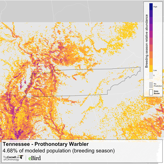
- eBird Abundance Maps
Abundance maps are a visual tool for land trusts to identify which species they should target on their properties and easements and strategize ways to manage lands to help reverse bird declines and improve habitat quality.
- eBird Trip Reports
Looking for new ways to tell stories on your land? eBird Trip Reports are a great way for land trusts to engage the birding community and share birding stories.
- Download eBird Data
eBird has open data access products available in several formats that can be helpful in your strategic conservation planning, scientific modeling, and analyzing data from your land trust hotspots.
- 2022 U.S. State of the Birds
The State of the Birds 2022 report sounds an alarm about steep population losses in virtually all habitats. The report identifies 70 Tipping Point species that have lost half or more of their breeding population since 1970, and are on tract to lose another half or more in the next 50 years.